


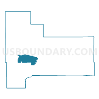
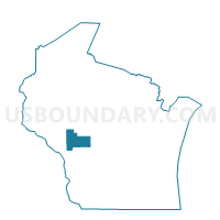
ALBION - T 1 Voting District, Jackson County, Wisconsin
About
Outline

Summary
| Unique Area Identifier | 694137 |
| Name | ALBION - T 1 Voting District |
| County | Jackson County |
| State | Wisconsin |
| Area (square miles) | 29.56 |
| Land Area (square miles) | 29.42 |
| Water Area (square miles) | 0.14 |
| % of Land Area | 99.53 |
| % of Water Area | 0.47 |
| Latitude of the Internal Point | 44.27080950 |
| Longtitude of the Internal Point | -90.95107930 |
Maps

Graphs
Select a template below for downloading or customizing gragh for ALBION - T 1 Voting District, Jackson County, Wisconsin


Neighbors
Neighoring Voting District (by Name) Neighboring Voting District on the Map
- ADAMS - T 2 Voting District, Jackson County, WI
- ADAMS - T 4 Voting District, Jackson County, WI
- ALBION - T 2 Voting District, Jackson County, WI
- ALBION - T 3 Voting District, Jackson County, WI
- ALBION - T 4 Voting District, Jackson County, WI
- Black River Falls - C 2 Voting District, Jackson County, WI
- Black River Falls - C 3 Voting District, Jackson County, WI
- BROCKWAY - T 1 Voting District, Jackson County, WI
- FRANKLIN - T 1 Voting District, Jackson County, WI
- IRVING - T 1 Voting District, Jackson County, WI
- IRVING - T 2 Voting District, Jackson County, WI
- MANCHESTER - T 1 Voting District, Jackson County, WI
- SPRINGFIELD - T 1 Voting District, Jackson County, WI
Top 10 Neighboring County Subdivision (by Population) Neighboring County Subdivision on the Map
- Black River Falls city, Jackson County, WI (3,622)
- Brockway town, Jackson County, WI (2,828)
- Adams town, Jackson County, WI (1,342)
- Albion town, Jackson County, WI (1,210)
- Irving town, Jackson County, WI (751)
- Manchester town, Jackson County, WI (704)
- Springfield town, Jackson County, WI (623)
- Franklin town, Jackson County, WI (448)
Top 10 Neighboring Place (by Population) Neighboring Place on the Map
Top 10 Neighboring Unified School District (by Population) Neighboring Unified School District on the Map
Top 10 Neighboring State Legislative District Lower Chamber (by Population) Neighboring State Legislative District Lower Chamber on the Map
Top 10 Neighboring State Legislative District Upper Chamber (by Population) Neighboring State Legislative District Upper Chamber on the Map
Top 10 Neighboring 111th Congressional District (by Population) Neighboring 111th Congressional District on the Map
Top 10 Neighboring Census Tract (by Population) Neighboring Census Tract on the Map
- Census Tract 9605, Jackson County, WI (4,824)
- Census Tract 9604, Jackson County, WI (4,268)
- Census Tract 9603, Jackson County, WI (4,077)
- Census Tract 9601, Jackson County, WI (3,987)